 |
JOURNEYS
A Coast Less Traveled
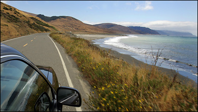
Peter DaSilva for The New York Times
SURFSIDE Mattole Road, a main thoroughfare on the Lost Coast, hugs the Pacific for a portion of its winding length.
|
By CHRIS DIXON
 |
|
|

|
1. |
|
2. |
|
3. |
|
4. |
|
5. |
|
|
|
|

|
|
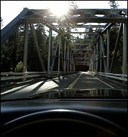
Peter DaSilva for The New York Times
HEADING SOUTH A bridge on Route 1 near Leggett takes travelers beyond the Lost Coast toward arty Mendocino.
|
|
|
|
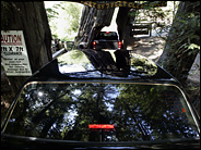
Peter DaSilva for The New York Times
INLAND Cars drive through a redwood tree.
|
|
|
|
|
 OUTH
of Oregon and far north of the Golden Gate, the Pacific coastal road
retreats inland, bypassing 120 miles of wild, rugged shoreline aptly
called the Lost Coast. In this isolated pocket of gargantuan redwoods,
surf-pounded mountains and hidden valleys, there's scant access to
road-trip staples like cellphone connections and four-lane asphalt. But
brave the bumps and guardrail-free switchbacks of the lonely Lost Coast
roads, and you'll drive into a wild, majestic California little changed
from the time when today's 2,000-year-old redwoods were just seedlings.
In some places, trees are so dense they nearly block out the sun. In
others, astounding scenery of precipitous cliffs, foamy sea and empty
beaches unfolds around every bend. OUTH
of Oregon and far north of the Golden Gate, the Pacific coastal road
retreats inland, bypassing 120 miles of wild, rugged shoreline aptly
called the Lost Coast. In this isolated pocket of gargantuan redwoods,
surf-pounded mountains and hidden valleys, there's scant access to
road-trip staples like cellphone connections and four-lane asphalt. But
brave the bumps and guardrail-free switchbacks of the lonely Lost Coast
roads, and you'll drive into a wild, majestic California little changed
from the time when today's 2,000-year-old redwoods were just seedlings.
In some places, trees are so dense they nearly block out the sun. In
others, astounding scenery of precipitous cliffs, foamy sea and empty
beaches unfolds around every bend.
A driver who loves a challenge
may have a great time hugging hairpin turns and plunging 1,000 feet in
three miles, but short hops are best on the serpentine Lost Coast
roads, especially if a passenger is reaching for the Dramamine. Start
in Eureka, taking a little time to stroll past fantastical Victorian
houses built by 19th-century lumber barons, before getting into the car
and heading south toward the Lost Coast. Pass the Humboldt Bay National
Wildlife Refuge, vast wetlands where 100,000 birds a day stop during
winter migrations, and then turn onto Mattole Road (California Route
211), and leave the traffic behind. MILE 19: FERNDALE
Victorian-era prosperity set off a contest to build the most
extravagant homes a century and more ago in Ferndale, and today its
1,400 residents live among turrets and gables. The Gingerbread Mansion
at 400 Berding Street, now one of the most opulent bed-and-breakfasts
in California, may win the prize for lavish decoration, and the Arnold
Berding House draws stares with an otherworldly set of five pruned
cypress trees out front that look like gigantic lime-flavored
Jujyfruits. Next to the Ferndale Artists Cooperative (580 Main Street),
where Stan Bennett has his gallery of perpetual-motion Magic Marble
Machines, the Ferndale Kinetic Museum preserves entries from a more
modern contest, a 38-mile human-powered land-sea race to Arcata, 38
miles north, held every Memorial Day weekend. Among the past winners on
display are a full-size 1963 Coupe de Ville convertible, a ground-bound
flying saucer and an oversize bumblebee. Mattole Road goes south
out of town, past two wooden posts holding a sign that reads "Capetown
+ Petrolia," marking the unofficial gateway to the Lost Coast. MILE 37: OCEAN HOUSE BEACH
After rolling through a high alpine forest at the start of the highest
coastal mountain range in the contiguous 48 states, and through a
former stagecoach stop called Capetown, downshift and check your
brakes. Twice. You're about to make an almost comically steep drop to
the sea. (By now it's plainly obvious why the locals call Mattole Road
the Wildcat.) After the exciting trip downhill, the road takes you on a
five-mile sweep along the ocean. Park along the way and look out over
the broad, windswept beach. You are just south of Cape Mendocino, the
westernmost point in the lower 48 states. You may spot an eccentric
lone windsurfer plying the icy waters, a gray whale or, near the
water's edge, any of the hundreds of happy, roaming cows lucky enough
to call this fog- and earthquake-prone strand home. MILE 42: PUNTA GORDA LIGHT
Past tiny Petrolia, where California's first commercial oil well began
operation in 1865 and quickly ran dry, take the narrow, paved
Lighthouse Road to a windswept gray sand beach, backed by grassland
hills and covered with rocks, kelp and shells. Plan to be here at low
tide, when you can explore the tide pools for enormous orange starfish,
abalone, sea cucumbers, sea urchins, crabs, whelks, sea anemones and
six-inch-long chitons, an ancient species also found in the fossil beds
of the Grand Canyon. It's at low tide (and only then) that you can hike
south on the 3.5-mile beach trail to the ruins of the Punta Gorda
Lighthouse - a place so utterly remote that state employees were once
sent to run the light as a punishment for bad behavior. Look out to sea
and ponder their lonely fate. Then, on your way back, stop to watch the
massive, argumentative stellar sea lions jockeying for flipper space
offshore on Sea Lion Rock. MILE 73: HONEYDEW
Mattole Road veers away from the rugged coastal cliffs and parallels
the Mattole River to Honeydew, a postage stamp of a town with a
smattering of Victorian farmhouses and some of the heaviest winter
rainfall in America. (It averages 110 inches a year.) The tiny general
store, which sells hot dogs and local produce, has the only gas pump
for miles and miles. Grab a beer or a soft drink and pull up a chair on
the front porch. You may meet William Ness, a weathered Navy veteran
and retired logger who holds court with a can of Budweiser. MILE 83: ALBEE HOMESTEAD
Alongside the Rockefeller Forest, the largest remaining old-growth
coast redwood forest in the world, the beautiful Albee Creek
Campground, just off the Mattole Road, occupies the long-abandoned farm
and apple orchard of John Albee. The remaining apple trees produce
copiously during the fall, feeding deer, bears and wild pigs. Fat,
mouthwatering blackberries and raspberries are free for the picking in
summer. Several trails lead into the 13,000-acre forest,
purchased for the State of California by the Save the Redwoods League,
with the help of John D. Rockefeller Jr., in 1931. Don't be startled to
see blissed-out hikers literally hugging the trunks of awe-inspiring
360-foot behemoths. At night, a staggeringly starry sky is all the
entertainment you'll need. MILE 105: AVENUE OF THE GIANTS
From the end of the Mattole Road south to Redway, the old Highway 101,
a twisty, two-lane blacktop wonder now called California Highway 254,
parallels the new. The 31 miles of it called the Avenue of the Giants
are lined by trees taller than 30-story buildings, with many places
along the way to climb out of the car and ponder your tiny place in the
universe. Though nearly 96 percent of California's ancient redwood
forests have been logged, a goodly representation of that last 4
percent is here in the 53,000 acres of the Humboldt Redwoods State Park. Scattered
in the clearings are shrines to roadside Americana, like the Eternal
Tree House, where a gift shop has been cleverly attached to a living
redwood with a one-room cabin inside its fire-hollowed trunk, and the
315-foot-tall Chandelier Tree ($3 to drive through a tunnel in a living
tree). At the dizzying Campbell Brothers Confusion Hill (75001 North
Highway 101, Piercy; 707-925-6456), gravity's effects are reputed to be
a little askew. Whether there's a glitch in elemental forces or not, at
the precariously perched Gravity House short people seem tall, water
appears to flow uphill and you find yourself walking on walls, leaving
the floor behind. At the amazingly hardy Chimney Tree (1111 Avenue of
the Giants, Phillipsville; 707-923-2265), burned hollow to its top by a
lightning strike and decapitated by a windstorm but still thriving, you
can see the sky 100 feet up from inside the trunk. MILE 150: SHELTER COVE
The most remote inhabited town in the lower 48 states may well be
Shelter Cove, accessible by leaving the Avenue of the Giants at Redway
for a rough 50-mile round trip on Briceland and Shelter Cove Roads.
Commercial fishermen had a small settlement here when, in 1966, land
speculators drew plans for a much larger community, laying out 4,000
lots. So far only about 400 houses have materialized, and regular
visitors still include deer, foxes, huge Roosevelt elk and black bears.
The town has a golf course, an airstrip, nine miles of beaches and
abundant spectacular scenery. There are several inns; the hilltop
Ashbrook is particularly nice. Mario's Restaurant, with a stunning view
of the coastline, serves fresh-baked bread and locally caught fish to
hikers, kayakers and sport fishing enthusiasts. MILE 262: USAL ROAD
At Leggett, California's Pacific Coast Road, Route 1, makes its
northernmost appearance, splitting off from Route 101 and wandering off
westward toward the Pacific. Follow it to the water, where it turns
south and the Lost Coast ends, and look for the words "Usal Road"
spray-painted on the pavement. They announce the turnoff for a
rutted, single-lane dirt trail heading north back into the Lost Coast
to the Sinkyone Wilderness State Park. If you have a four-wheel-drive
vehicle and a friend with another to accompany you into the wilderness,
you can try a portion of it. Five and a half miles and a few hours
(literally) from the turnoff, you'll descend a precariously steep slope
to Usal Beach, strewn with boulders and logs and perched ominously
between gloomy cliffs and enormous roaring waves. You may not be alone;
off-roaders like testing their machines on this terrain. After your
sojourn at the beach, turn back. It's possible to continue on dirt
roads all the way back north to Shelter Cove and then to Honeydew, but
it's a time-consuming, treacherous trip. MILE 300: MENDOCINO
As you drive south on Highway 1, civilization asserts itself
picturesquely with increasing numbers of farms and tiny hamlets. For a
last taste of isolation, stop two miles north of Westport at the bridge
at Westport-Union State Beach and hike down to the roaring ocean. (Be
wary here in the fall, when the first massive North Pacific swells
begin bearing down: lulls between the biggest waves can last as long as
10 minutes, leaving mammoth seas to sweep in seemingly from nowhere.)
Back on Route 1, drive south through the burly old Army town of Fort
Bragg and into its famously arty cousin, Mendocino, for a soft landing
after an exhilarating trip. The wines are local, the sea is tame and
the shops are charming. And at the Whitegate Inn Bed and Breakfast in
Mendocino, you can ask for the French Rose Room, previously booked by
Julia Roberts, Bill O'Reilly, Mel Gibson and other celebrities. Where Redwoods Guard the Shore THE
best time of year for a trip to the Lost Coast is April to October,
when sunshine is most likely, winds are relatively calm and fog is at
its minimum. The commercial airport nearest to the Lost Coast is
Eureka/Arcata, 16 miles north of Eureka, Calif., served by Horizon Air
and United Express. Car rentals are available there. The
preserved Victorian buildings of Eureka, a town of 26,000 about 100
miles south of the Oregon border, include several now used as inns. The
Carter House Inns (301 L Street, 800-404-1390) is a cluster of four
Victorian houses that includes an inn, restaurant and wine shop. Its 32
rooms start at $155 year-round. In Ferndale, the Gingerbread
Mansion Inn, (400 Berding Street, 800-952-4136) has 11 rooms and suites
starting at $160; $129 from October 1 to March 31. The Albee
Creek Campground, near Honeydew in Humboldt Redwoods State Park, is
just off the Mattole Road, five miles west of Route 101. It has 40
sites and can accommodate R.V.'s up to 33 feet long, though there are
no hookups. It has hot, coin-operated showers and a pay phone. Sites
are $20 a night from mid-May to mid-September; $15 a night the rest of
the year (reservations, 800-444-7275). The Ashbrook Inn in
Shelter Cove (578 Hillside Drive, 707-986-7109) is on a hillside
overlooking the Pacific at 1,000 feet above sea level. Its three guest
rooms, all with kitchenettes, decks and high-speed Internet access,
start at $170 year-round. Nearby, Mario's Restaurant & Bar (533
Machi Road, 707-986-1401) has an equally stunning coastline view. In
Mendocino, the six rooms and one cottage at the Whitegate Inn Bed &
Breakfast (499 Howard Street, 707-937-4892) are $169 to $309 year-round. Special Offer: Home Delivery of The Times from $2.90/week.
|
|
| | Advertisement
|
|
